
The 2025 Terrible Two offers three rides that take in some of the most spectacular and challenging scenery that Sonoma County has to offer. Volunteers will be there to keep you going at our legendary rest stops which will be well stocked with plenty of food and hydration.
Routes are now final and we're pleased that Wohler Bridge has been re-opened allowing us to avoid passing through central Healdsburg. The route collection can be viewed HERE.
Terrible Two
200 miles | 17,000 feet
5 Full Aid Stations | 4 "Leapfrog" Support/Water Stops
The 2025 Terrible Two route has been redesigned to remain entirely within Sonoma County and includes the full Geysers loop. These changes reduce the amount of elevation in the first 75 miles of the ride which we hope will make the first part of the day fly by and translate to faster finishing times.
The rollout will be familiar to repeat riders as it passes through Santa Rosa and out on Bennett Valley Rd. But then the route loops back on Warm Springs Rd and Lawndale to take Hwy 12 to Calistoga Rd. Riebli connects to Mark West and then River Rd to Laughlin. The route passes by Sonoma County Airport to connect to Westside and West Dry Creek en route to the Geysers, the first big climbing challenge of the day at around mile 75. The route hits Stewarts Point-Skaggs Springs Rd at mile 110 for the most challenging part of the day. Hwy 1 offers much needed cooler temps, allowing riders to recover before the last big climb of the day, Fort Ross Rd. Before you know it you'll be dropping into Caz and heading back to Sebastopol!
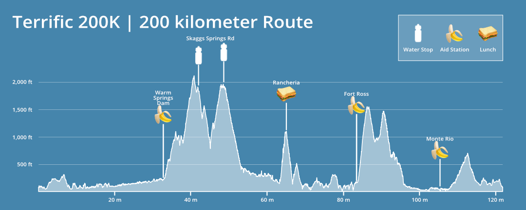
Terrific 200K
122 miles | 11,400 feet
4 Aid Stations | 2 Water Stops
The Terrific 200K route takes on the formidable Stewarts Point-Skaggs Springs Rd, which is the cornerstone of the Terrible Two, in a beautiful and challenging 200K format.
This year's route similar to prior years. The route connects to the main event via the rolling wine country roads of Westside and West Dry Creek. The real climbing begins at around mile 42 as the route takes Stewarts Point-Skaggs Springs Rd all the way to the coast. An almost 20 mile section of Hwy 1 provides spectacular views, cooler temps, and a reprieve from climbing. Then it's back to work on Fort Ross Rd which climbs abruptly to Seaview and then follows an asphalt ribbon into Cazadero. With the real climbing done you can enjoy the final miles that roll back to Sebastopol via Monte Rio and Occidental.
Tremendous Super Century
122 miles | 8,500 feet
3 Aid Stations | 1 "Leapfrog" Support/ Water Stop
The Tremendous Super Century routes focus is the Geysers loop which offers steep climbs, sinuous descents, outstanding views, and some broken pavement. The ride heads north from Sebastopol taking Gravenstein Hwy to Vine Hill and then winds around the north side of Sonoma County Airport across to Faught Rd, onto Chalk Hill Rd and Hwy 128. The route hits the Geysers at mile 31 and descends into Cloverdale at mile 56.
After all the climbing and descending you deserve a break at Warm Springs Dam. From there the journey south follows the world class wine country roads of West Dry Creek and Westside to Healdsburg. You'll swing by Forestville and then take the wonderfully flat River Rd to Monte Rio. From there, Bohemian Hwy winds into Occidental and Graton Rd provides a final thrilling descent on the way back to Sebastopol.
Elevation Profiles


.png)
